Gold Butte National Monument
Mesquite's wild backyard — 300,000 acres of red sandstone, rock art, and ghost-town history just south of the Virgin River.
A 300,000-Acre Backcountry Just Past Mesquite
Gold Butte National Monument covers roughly 300,000 acres of southeastern Nevada, tucked into the far northeastern corner of Clark County between the Virgin River, Lake Mead, and the Arizona line. For most travelers the gateway is Mesquite: from town you cross near the Bunkerville Bridge and follow Gold Butte Road south into a landscape that flips quickly from highway sprawl to raw Mojave Desert.
This is a place of deep red and orange sandstone, twisting canyons, and wide silence. It's also one of the least developed monuments you'll visit anywhere in the Southwest. There are no entrance booths, no visitor center, and no concession stands once you leave the pavement. What you get instead is room to roam, ancient rock art, abandoned mines, and the kind of scenery that rewards anyone willing to drive a little farther than the next person.
If you're mapping out a wider trip, Gold Butte pairs naturally with the other big backcountry preserves in the region — see the full landmarks guide and the nearby Grand Canyon–Parashant National Monument, both of which share the same remote, high-clearance character.
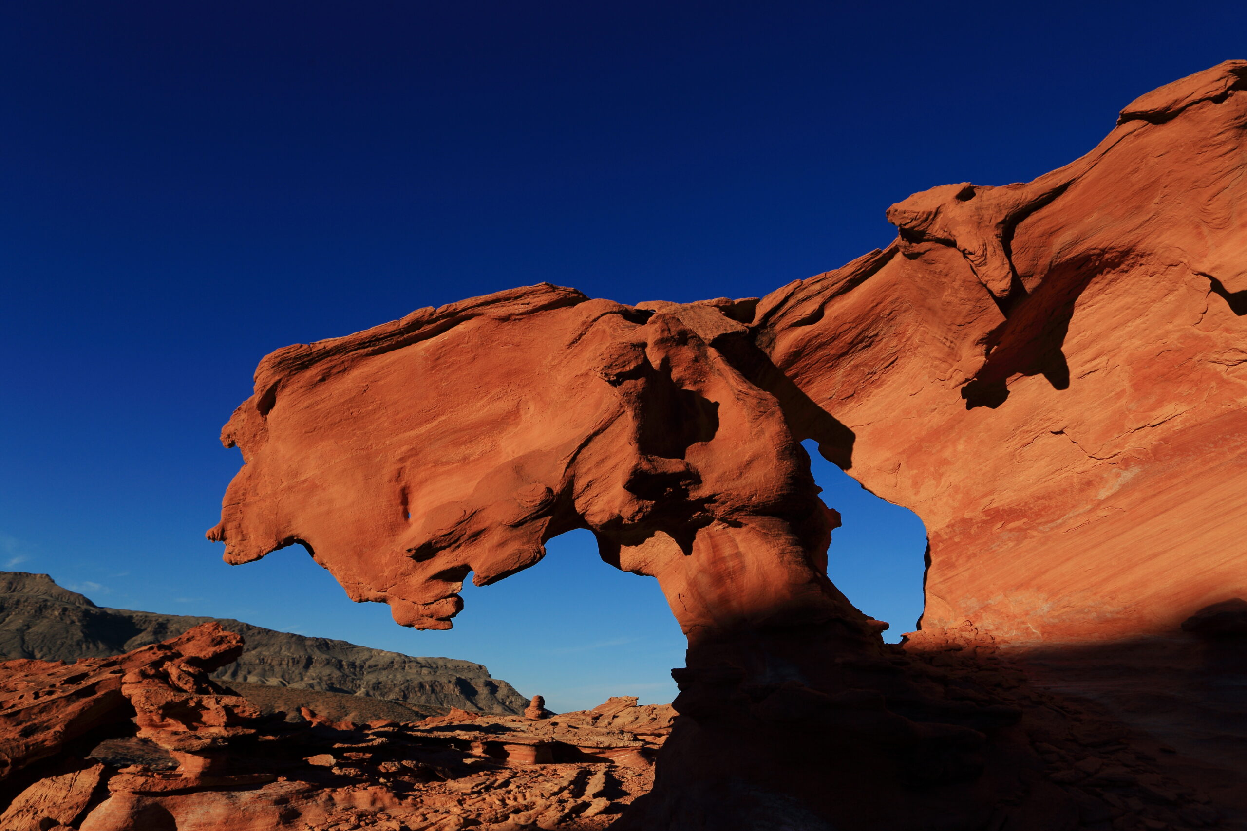
Whitney Pocket and the Sandstone Country
Whitney Pocket is the single best first stop, and the most photographed corner of the monument. Sitting near the north end, it's a jumble of cream, rust, and amber sandstone domes and hollows that stand out sharply against the gray peaks behind them. The colors come from a geologic history of volcanic activity, erosion, tectonic shifting, and old flooding — all of it written into the rock layers you can read like pages.
Whitney Pocket is popular with campers, ATV riders, and off-road travelers, and it carries its own history: rock-art panels record its deep human history, and a brief mining boom passed through in the early 1900s. You can reach the main area on a rough graded road, but anything beyond the obvious pullouts calls for four-wheel drive and good ground clearance.
Elsewhere in the sandstone country, look for Little Finland, a maze of wind-carved rock fins and delicate formations that feels almost sculpted, and the Seven Keyholes, a string of natural rock openings that draw scramblers and photographers. For high-country hikers, Virgin Peak rises to 8,074 feet inside the monument — the tallest point in the Virgin Mountains, with stands of yellow pine high on its slopes.
Petroglyphs and Ancient Rock Art
Gold Butte is as much an archaeological treasure as a geologic one. Native peoples carved petroglyphs into the dark desert varnish here over many centuries, and the panels that survive offer a rare, direct window into the beliefs and daily life of the region's earliest inhabitants.
The most famous is the Falling Man Petroglyph, an enigmatic figure that has intrigued visitors for generations — many read it as a warning, fitting given the tall, slick rocks nearby that can genuinely endanger climbers. Close to it, don't miss Newspaper Rock, a single boulder crowded with petroglyphs of wildly different sizes and styles. Downstream from Whitney Pocket, the 21 Goats Petroglyphs (once called "Indian Writings") feature a herd of goat figures alongside symbols whose meaning is still debated.
These carvings are fragile and irreplaceable. Look, photograph, and keep your distance — never touch, chalk, or trace them. Oils from skin and any added pigment accelerate the very weathering that has so far failed to erase them.
Mining History, Ghost Towns, and Desert Wildlife
Long before it was a monument, this was working country — laced with old mining claims and travel corridors used as far back as the 18th century along routes tied to the Old Spanish Trail. The relics are part of what makes a day out here feel like time travel.
- Gold Butte Townsite — Once home to nearly 2,000 fortune-seekers, the old town is now decaying structures and open mine shafts. Hunt for the "Cradle of Humanity," a hole in a large boulder perfect for a group photo, and pay respects at the gravesite of longtime residents Bill Garrett and Art Coleman.
- Gold Butte Cistern — A stone water-storage structure built by the Civilian Conservation Corps during the Great Depression, a quiet monument to desert water and Depression-era labor.
- Lakeside Mine — Worked on and off from 1937 to 1956, it sits at the monument's far reaches with miner's-camp remnants, several adits, and a headframe overlooking Lake Mead.
- Nickel Creek — About 5.8 miles from Bunkerville, where flecks of garnet glint in the streambed and a spring runoff briefly turns the wash into a desert oasis.
Wildlife is woven through it all. The protected desert tortoise lives here, along with Joshua trees, bighorn sheep, a long roster of birds, and the area's storied wild burros — descendants of pack animals from the region's settlement and mining days.
Know Before You Go
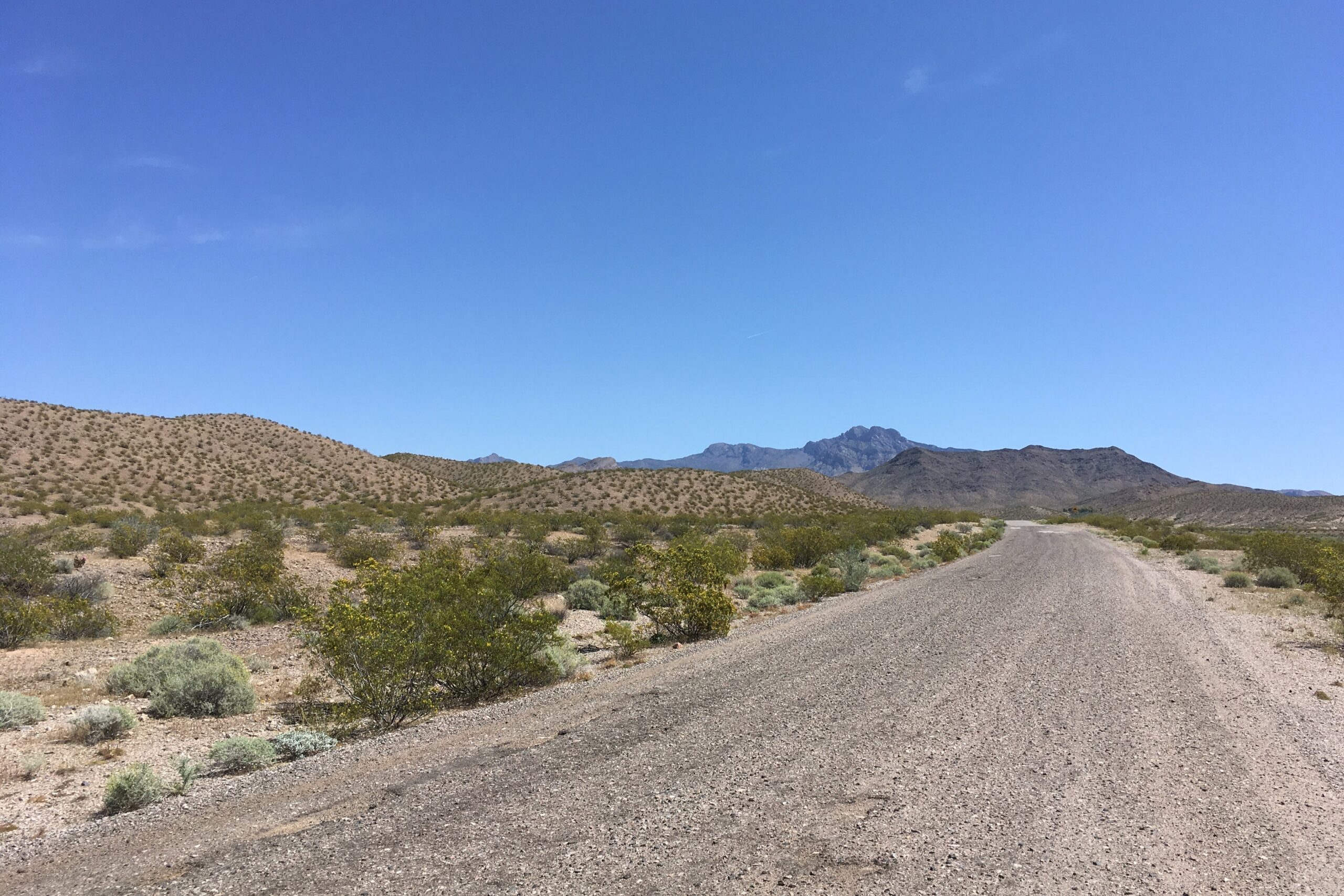
Gold Butte is rewarding precisely because it's remote, which means it asks more of you than a paved national park. Plan like the backcountry trip it is.
- Vehicle: A high-clearance 4x4 is strongly recommended. Some lower stretches near the entrance are passable in a careful 2WD with moderate clearance, but the interior roads — and any route to Whitney Pocket's far pockets, Little Finland, or the mines — get rough fast. Roads wash out after storms.
- Season: Fall through spring is ideal. Summer in this part of the Mojave is brutal; even experienced locals have been turned back from remote sites by the heat. Aim for cooler months and an early start.
- Water and fuel: Bring more water than you think you need, plus food, a full tank, a spare tire, and a paper map or downloaded offline maps. Cell service is unreliable to nonexistent.
- No services: There are no stores, gas, or reliable potable water inside the monument. Stock up in Mesquite or Bunkerville first.
- Leave no trace: Pack out everything, stay on existing roads to protect tortoise habitat, and never disturb petroglyphs, structures, or artifacts.
One note for context: the 2016 monument designation by President Obama remains a sore point for some local ranchers, part of a long-running debate over federal land control in the region. Travel respectfully — you're moving through working country and sacred history at once.
For trail ideas, ATV routes, and more backcountry destinations across the Arizona Strip, browse the recreation guide before you set out.
Plan Your Trip Around the Strip
Base your trip in one of the region's gateway communities.