Toroweap Overlook
Three thousand feet straight down to the Colorado River — the Grand Canyon's most dramatic roadside view, at the end of sixty miles of dirt.
Why Toroweap Is Unlike Any Other Grand Canyon View
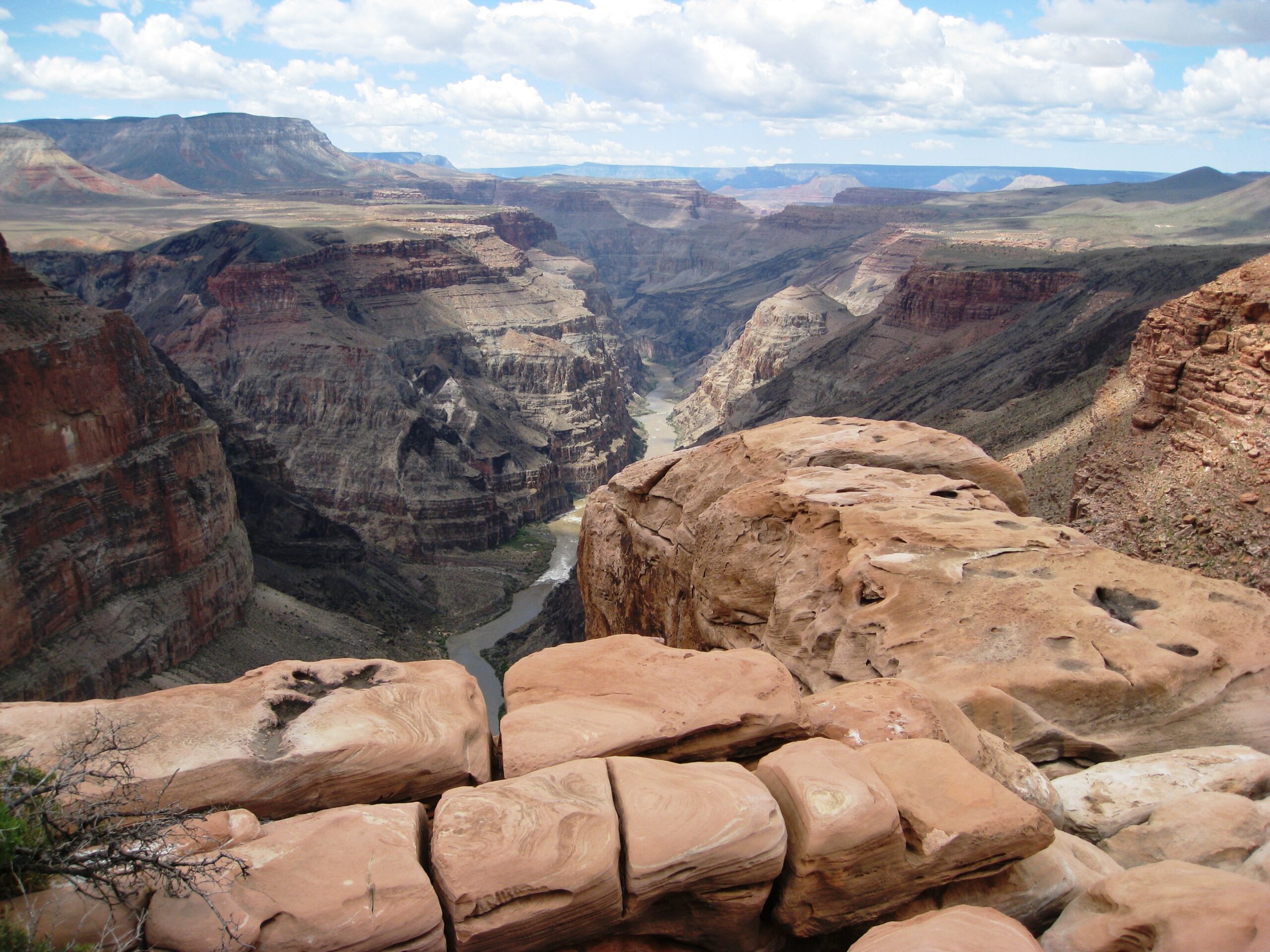
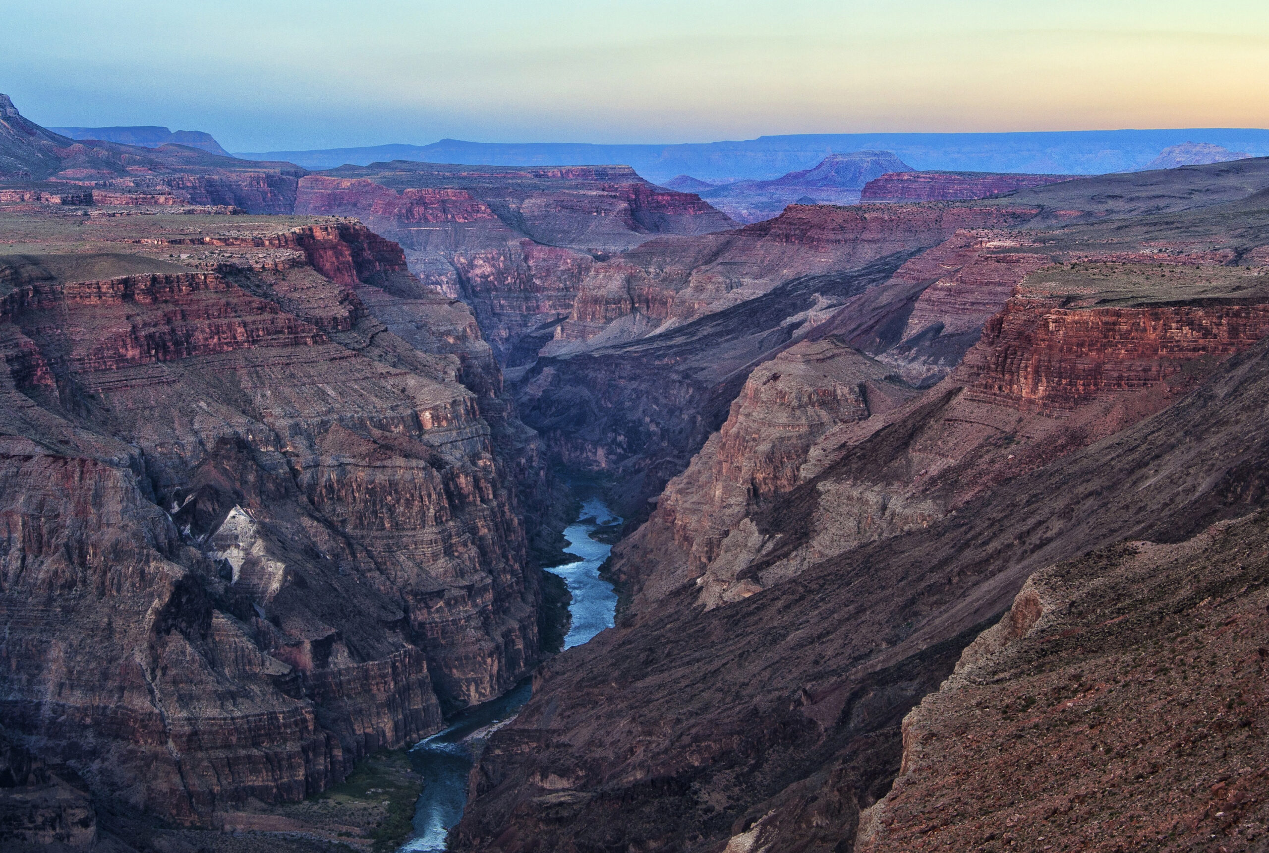
If you've only seen the Grand Canyon from the busy South Rim, Toroweap will rearrange your sense of the place. Here there is no railing, no shuttle bus, and no crowd between you and the void. The rim simply ends, and the rock falls away in a single, nearly vertical plunge of roughly 3,000 feet straight down to the Colorado River. Stand near the edge and you can watch the river churn through Lava Falls far below, hear rapids if the wind is right, and take in a sheer drop few overlooks on Earth can match.
This is one of the most dramatic vantage points anywhere on the Grand Canyon's North Rim, and it has long drawn photographers and seasoned adventurers willing to work for the reward. The payoff is a raw, unframed view of the canyon at its most severe, with nothing softening the scale.
.jpg)
Toroweap or Tuweep? A Quick Note on the Name
You'll see both names used, and they refer to the same corner of Grand Canyon–Parashant country. "Tuweep" generally refers to the broader area and the ranger station, while "Toroweap" is the name most often attached to the overlook itself. The whole district sits within the western reaches of Grand Canyon National Park, far from the developed rims, on the remote tableland north of the river that defines the Arizona Strip.
Getting There: A Long Drive on Dirt
There is no paved route to Toroweap. Reaching the overlook means committing to roughly 60 miles of unpaved road, most travelers turning off State Route 389 west of Fredonia and grinding south across open Strip country toward the rim. The early miles are often graded and passable, but conditions deteriorate the closer you get, and the final stretch near the rim is rough enough to demand a high-clearance vehicle.
This is not a drive to attempt casually or in a hurry. Plan on hours behind the wheel each way, expect washboard and rock, and understand that the road can become impassable when wet. After rain or snowmelt, clay sections turn to grease and stranded vehicles are a real and recurring problem here.
Come Prepared: This Is True Backcountry
The remoteness that makes Toroweap so special is also what makes it unforgiving. There are no services of any kind out here — no fuel, no water, no cell coverage, no shop to buy a forgotten supply. You are responsible for everything you bring, and for getting yourself back out. Treat the trip the way you would a serious wilderness outing, not a scenic drive.
- Vehicle: High-clearance is strongly recommended, and 4x4 is wise for the final miles and for any chance of weather.
- Spare tire: Carry at least one good spare plus the tools to change it — sharp rock punctures tires regularly on this road.
- Water: Bring more than you think you need, for both people and engine, since none is available on site.
- Fuel: Top off in town before you leave; the round trip is long with no stations anywhere along the way.
- Essentials: Food, navigation that doesn't rely on cell signal, a first-aid kit, and extra layers for the open, exposed terrain.
Fuel up and stock up in a Strip community before heading out. Towns like Kanab and Fredonia are practical last stops to fill the tank and load up on supplies.
At the Edge: Safety and Respect
The lack of guardrails is part of what makes Toroweap unforgettable, and it's also why people get hurt here. The rim is uneven, the rock can be loose, and a single misstep at the edge has fatal consequences. Keep well back from the lip, watch children and pets closely, and resist the urge to inch out for a better photo. The view is just as staggering from a few safe feet back.
Because this is national park land, you're also a steward of an extraordinarily fragile place. Pack out everything you pack in, stay on established roads and pullouts, and leave the desert exactly as you found it for the next traveler who makes the long haul out.
Plan Your Visit: Know Before You Go
Toroweap rewards travelers who plan carefully and time their trip well. A little homework before you leave the highway goes a long way out here.
- Season: Spring and fall offer the most comfortable temperatures. Summer brings extreme heat and monsoon storms that can flood and ruin the road; winter can bring snow and mud that close access entirely.
- Permits & camping: Overnight camping in the area is by permit and at a small primitive campground with very limited sites — secure arrangements through the National Park Service in advance rather than assuming you can stay on arrival.
- Time it right: Give yourself a full day. The drive in and out eats most of the daylight, so leave early and don't push your luck returning after dark on unfamiliar dirt.
- Tell someone: Share your route and expected return with a person back home, since you'll be far beyond cell coverage and unlikely to see other vehicles.
Toroweap pairs naturally with a wider exploration of the region's remote landmarks and backcountry recreation. If you need help planning a route across the Strip or have questions about current conditions, reach out through our contact page before you set off.
Plan Your Trip Around the Strip
Base your trip in one of the region's gateway communities.